For schools, polygons are twice as nice!
Welcome to our Targeted Editing series where today you can try to decide which fruit cake is edible, or make OpenStreetMap data incredible! (Both take about the same amount of time.)
Read on for some basic uses for school polygons, and where you can check to see if you can use your local knowlege to add some polygons where they are needed.
How can school polygons be used?
Help with map rendering. Map rendering involves taking the raw data and turning it into a map. A map label is great to have, but a polygon is even better.
Help with display order. In many cases, the size of a school indicates significance. When schools have polygons, the size of the school can be used to determine how much you should zoom in to the map before it appears. Bigger schools can be shown sooner than smaller schools.
Help with search rank. When searching, a search engine can use a number of things to prioritize what features are returned. Some examples might be associated attributes like type, or even the physical size of a feature. Since points have no area, adding a polygon could be an excellent enhancement.
We are missing some school polygons here!
Check out this pie chart for schools in Atlanta:
We have some work to do!
How you can help improve schools without polygons:
Here is a map styled by Peter Richardson & Nathaniel V. Kelso showing schools that don’t have polygons. To add a polygon for a school that is only represented by a point, hover over one of the bright blue highlighted school points to bring up an info bubble with links to editing tools that can be used to add the missing polygon.
(This map is interactive! Open full screen ➹ )
See the wiki pages for amenity=school for lots of details and a great example. A polygon tagged amenity=school should cover the grounds of the school, not just the building footprint, while the school building itself should be tagged as building=school. This diagram from the OpenStreetMap Wiki gives a good overview of the tagging options.
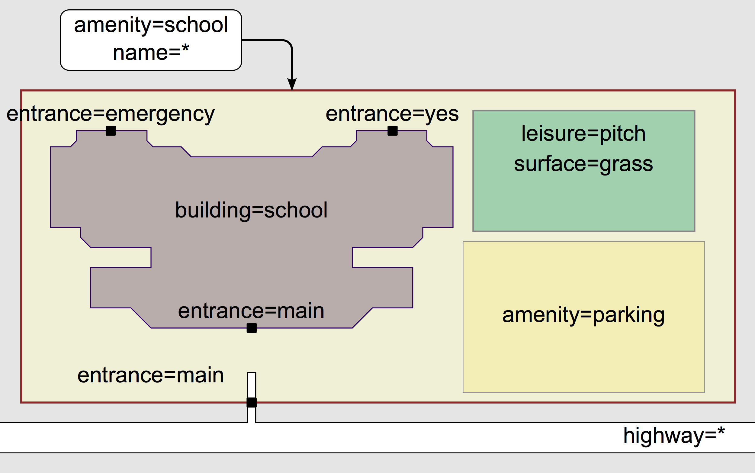 image via OSM wiki
Including your sources with the source key is incredibly helpful. This includes the imagery you use to trace features, and any authoritative websites as long as they allow their use for this purpose.
(If you find a school that appears to have a polygon, but it’s still highlighted, you may have found a duplicate or a building that was tagged amenity=school instead of the school grounds. Improving those is a topic for another post…)
Not familiar with Atlanta? Search or pan over to your home town to contribute your local knowledge to the map. You will see your changes right away in OpenStreetMap. You will also be able to see them in all versions of the Mapzen Vector Tiles within an hour, including the map right here on this page!
Need instructions on how to edit with iD? Here are some links to outstanding tutorials from LearnOSM, the OpenStreetMap wiki, and the United States Department of State’s Humanitarian Information Unit:
Are you a mapping wiz and interested in a more advanced editor? Try out JOSM with excellent documentation from Mapbox.
Thanks, and please check back soon for the next in our series!
All the posts in the Targeted Editing series:
